
Cambridge IELTS Academic 1 Writing Task 1 Model Answers
TEST - 2
The diagram below shows how the Australian Bureau of Meteorology collects up-to-the-minute information on the weather in order to produce reliable forecasts.Write a report for a university lecturer describing the information shown below.
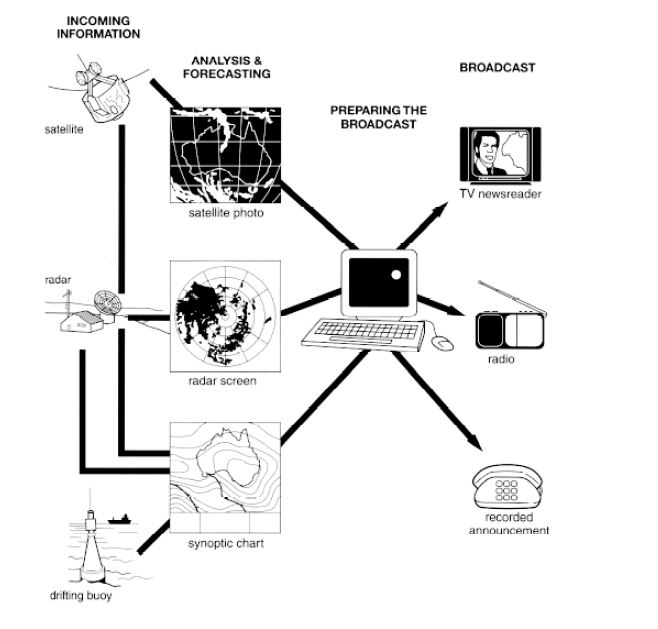
The diagram illustrates how the most recent information about the weather is collected by the Australian Bureau of Meteorology to generate reliable weather forecasts.
Overall, information collected through various instruments can be broadcasted, after it has been analyzed, forecasted, and prepared for broadcasting.
Initially, the incoming information is collected using three instruments called as satellite, radar, and drifting buoy. Satellite photo is used to visualize data collected using satellite, radar screen is available to view data collected via radar, and the data collected by a drifting buoy can be visualized using a synoptic chart.
This information is then analyzed to generate an up-to-date weather forecasting report, and it is then forecasted further so that it can be prepared for broadcasting on different mediums for the general public. After this, the final information which is in the form of weather forecasts is broadcasted among people via TV newsreader, radio, and recorded announcements.
TEST - 4
Chorleywood is a village near London whose population has increased steadily since the middle of the nineteenth century. The map below shows the development of the village. Write a report for a university lecturer describing the development of the village.
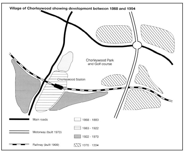
The map illustrates the development and an increase in the population of Chorleywood village (near London) from 1868 to 1994.
Overall, the progress has steadily increased in the village in the given period. Transportation facilities had also improved.
Earlier, there was a small village near to the Chorleywood Park and Golf course, which was at the center. Also, two main roads were intersecting each other. Until 1922, some more settlement areas developed adjoining to the previous residential area. There was an increase in the settlement areas from 1922 to 1970 on the left and right side of the development that occurred from 1883 to 1922. A railway line was built in 1909, and a railway station was also constructed in the area developed from 1883 to 1922.
The motorway constructed in 1970, and it crossed both the main road and railway line. A roundabout was also built at the intersection of the motorway with the main road. A major development in the settlement areas also occurred after 1970. These areas are on both sides of the motorway.